Marble Mountain - Skye Valley
Distance: 110 km (67 miles)
Starting Point: Port Hastings; Mabou; Whycocomagh
Region: Cape Breton
Terrain: Flat to slightly rolling
Meandering through the heart of Cape Breton, this tour connects the most popular touring areas on the Island. The Cabot Trail, Creignish Hills (Ceilidh Trail), Mira River, and historic Louisbourg areas connect with mainland Nova Scotia by way of this route. The tour runs from Port Hawkesbury, around the west side of Lake Bras' d'Or, meets the start of the Cabot Trail, and then goes to the West Coast by way of Lake Ainslie. By doing part of this tour, you can tailor any trip of island. Connecting with other Cape Breton Island tours of the Nova Scotia Bicycle Book, you can make a near perfect tour, without any long stretches of major roads.
Isle Madame
Distance: 58 km (32 miles)
Starting Point: Louisdale
Region: Cape Breton
Terrain: Slightly rolling
River Bourgeois, D'Escousse, Petit-de-Grat... this area is pure Acadia. French since 1650, Isle Madame is named for Madame de Maintenon, second wife of King Louis XIV. This is a land of barren coasts, with small spruce trees. This is as perhaps as close as Nova Scotia gets to the allure of Newfoundland.
The villages are among the prettiest in Nova Scotia. The Nova Scotia Bicycle Book guides bikers around the Island, included to villages it recommends, such as Little Anse, and Sampson Cove near Petit-de-Grat. Narrow roads run seemingly all over the place, hard to tell apart from driveways. This guide selection is great for casual cyclists.
Washabuck
Distance: 58 km (35 miles)
Starting Point: Little Narrows; Iona; Whycocomagh
Region: Cape Breton
Terrain: Very hilly
This is a truly remarkable route. Surrounded by water, in the heart of Cape Breton, it is a wonder how an area this attractive has remained so unspoiled. Iona, with only a couple of hundred people is the largest place along the
entire route. An area of original Scottish settlement, along the roads, many old homesteads stand abandoned, instilling a melancholy, introspective mood
.
This tour of the Nova Scotia Bicycle Book follows what many consider to be probably the cleanest inland sea on earth. Nova Scotia's magnificent Bald Eagles claim this as their major nesting area. Thriving on the highland ridges, this is considered perhaps the most healthy population in the world. Rainbow Trout and other of their favourite fish still populate the clear waters. The huge birds can often be seen overhead, scanning the waters, their wings spreading as much as 1.8 m (6 ft.) wide.
The book suggests a starting point near Whycocomagh.
Lake Ainslie
Distance: 70 km (44 miles)
Starting Point: Whycocomagh; Inverness
Region: Cape Breton
Terrain: Rolling
Circled by tall hills of dense fir trees, Triangle shaped Lake Ainslie is the largest body of fresh water in Cape Breton. The Gaelic language once prevalent here is still alive, but no longer one of everyday business use. Ties with their heritage are strong here, the tiny area even has its own tartan.
This pleasant route outlined in the Nova Scotia Bicycle Book is easy to follow- once at the lake, you are given a guided tour around its edge. The book starts you off from Whycocomagh, although it is just as good starting from Inverness.
Creignish Hills - Ceidlh Trail
Distance: 113 km (70 miles)
Starting Point: Margaree Harbour; Port Hastings; Mabou
Region: Cape Breton
Terrain: Rolling
Cape Bretoners are looked upon by the rest of Canada as among its most warm, hospitable and happy people. Perhaps you will gain insights into their pleasant dispositions after you experience the beauty and spirit of this rugged coast.The "Ceilidh Trail" and it's highlands echo with the sounds of bagpipes, fiddles, and song.
The traffic is low, the scenery is magnificent. There is not one mall or fast food strip along the entire coast! While this many make development agencies cringe, for the true visitor, it is a boon. The terrain is rolling, but only hilly in a few sections. Between Margaree Harbour and Port Hastings, highway #19 has several areas with access to the Gulf of St. Lawrence. This craggy shore shares some of the warm waters of Prince Edward Island and northern Nova Scotia mainland. The water is warm, due to the shallow depths of the Northumberland Strait. The entire shore along the Creignish Hills is famous for its sunsets.
This tour of the Nova Scotia Bicycle Book begins in Margaree Harbour.
Mira / Louisbourg
Distance: 103 km (64 miles)(shorter tour possible)
Starting Point: Mira Gut Provincial Park; Mira Gut
Region: Cape Breton
Terrain: Flat to gently rolling
A myriad of islands, numerous peninsulas and sheltered coves, this tour guides you along one of the longest and most attractive rivers in Nova Scotia. The slow and tranquil Mira provides easy shoreline cycling within an atmosphere of solitude. Occupying an elongated, narrow valley, the Mira is thought to follow an old fault line.
Long been considered an easy canoe route, for cycling, it's shoreline still lies largely undiscovered. Despite its proximity to the Fortress of Louisbourg, it remains almost unknown by outsiders
Cabot Trail 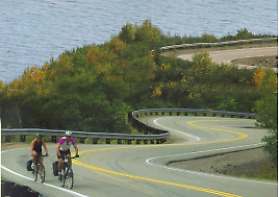
Distance: 305 km (190 miles)
Starting Point: Baddeck; Margaree; Nyanza; Englishtown
Region: Cape Breton
Terrain: Challenging
Described as having some of the most spectacular scenery in North America, this is overwhelmingly Atlantic Canada's most popular bicycle ride. Here, you wind your way into Cape Breton's forested highlands, the tundra-like barrens on top resembling the Canadian north. Coming down the steep mountain cliffs you scan across valleys, or directly down at the ocean.
This is not a trip to be taken lightly! With several large climbs, it requires a moderate level of fitness. Elevations may not seem that lofty to many, especially to those who have cycled in mountainous regions. Remember however, that along the Cabot Trail you rise and fall from sea level, not already at high points of elevation. Edged by the ocean, there is also often no room for grading, you must go straight up. Just because a road is marked "The Cabot Trail does not mean that it is the best road to take! This tour offers you the best of the Cabot Trail, plus some scenic alternate sections.
This is the tour has the most detailed description of the Nova Scotia Bicycle Book. Topics considered are the best time to go, a complete detailed comparison of "clockwise" vs. "counter-clockwise" directions with the benefits and drawbacks of each, detailed terrain breakdowns, traffic suggestions, climate notes, and other items.
Meat Cove
Distance: 58 km (32 miles)
Starting Point: Cape North
Region: Cape Breton
Terrain: Very hilly
Meat Cove is the end of the line. You don't go there on your way to somewhere else. You can go out just part way, it makes a great spot for a part-day or evening run. Go as far as the landing site of explorer John Cabot, and return, making a good mini-ride from Cape North. You could go even further, to the gorgeous cove of Bay St. Lawrence.
If your nerve doesn't fail, you can go all the way to Meat Cove, where without a doubt you will be able to claim you have gone to the top of Nova Scotia!
A strongly defined escarpment extends along the shore. Stretching from the Cabot trail to the tip of the province, it is, in fact, the tail end of the Appalachian chain, making one last appearance before dipping into the Atlantic. This challenging terrain will stalk you as you make your way along the lonely coast. While not mountainous, you should expect rolling hills, with several climbs in the (500 ft.) range.
All these tours do you find in:
Nova Scotia Bicycle Book
Gary Conrod
308 pages, 8 1/2 x 11, paper
ISBN 0-920890-80-8
Gary Conrod has discovered a Nova Scotia cycling trip just for you, whether you are seeking an easy ride along a country lane, or a challenging ride up a seacoast mountain. His huge book is an invaluable resource for fully enjoying one of the world's finest cycling destinations. Everything is included from over 100,000 kilometers of cycling in Nova Scotia.